State of Andhra Pradesh
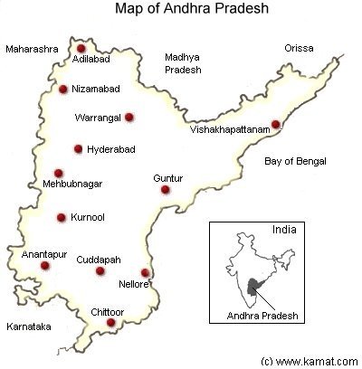
A Map of Andhra Pradesh showing important cities
![]() This is on older map. The state was divided into two in year 2014
This is on older map. The state was divided into two in year 2014
Andhra Pradesh is a large (area: 275,068 sq. kms), important and picturesque province in India comprising of interesting rock formations, many lakes and low hills. Tribes of Lambanis or Gypsies have inhabited the region for many hundreds of years, and are part of the ethnic culture. The official language is Telugu, although Urdu is widely spoken in and around Hyderabad, the capital city. The state encompasses the former princely state of Hyderabad, the richest and largest state at the time of independence in 1947. Centuries ago the Aryan push southwards ended in Andhra Pradesh, resulting in a fascinating mixture of Aryan and Dravidian customs, culture and art. Today this is still evident in the language and in the deep respect given to the ancient heritage. The Salarjung museum in Hyderabad houses an extraordinary private collection which contains some beautiful and unique objects. The temples in Lepakshi town of Anantapur district are home to some of the most beautiful paintings of Vijayanagar period. Tirupati is the richest temple town in India where Lord Venkateshwara is worshiped. Warrangal was the ancient capital of Kakatiyas, during which period Marco Polo visited it and has described it in glowing terms.
The sixteenth century Charminar was built by Sultan of Golkonda at the center of Hyderabad city. Its arched portals face the four cardinal points while its four minarets are each four stories high.
![]()
See Also:
- See topics on neighbors of Andhra Pradesh: Karnataka, Tamil Nadu, Orissa, Maharashtra, Madhya Pradesh
